|
|
Salar Uyuni
Translated by PROMT-Online-Translator
| Country: |
Bolivia |
Location: |
Salar Uyuni |
| Rating: |
Unbelievable beautiful landscape |
| |
| |
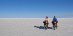
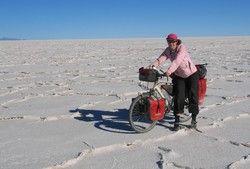
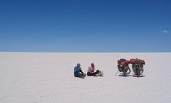 Salar Uyuni: The next day, finally, then it goes on
the Salar de Uyuni, the biggest and highest salt lake of the earth
on 3653 m. After many washing board runways and sandy runways of the
last days cycling on the smooth and firm salt crust is a true relief.
We were real a little bit anxiously because of the orientation on
the Salar, however, thanks to the road description of the Swiss and
the black lanes not to be overlooked (thanks to tyre wear) of the
tourist jeeps the orientation is absolutely trouble-free. About 40
km we go dead-straight northwards up to Isla Inkawasi who lies here
in the middle of the Salar. One can see the island, by the way, already
from 30 km of distance. Salar Uyuni: The next day, finally, then it goes on
the Salar de Uyuni, the biggest and highest salt lake of the earth
on 3653 m. After many washing board runways and sandy runways of the
last days cycling on the smooth and firm salt crust is a true relief.
We were real a little bit anxiously because of the orientation on
the Salar, however, thanks to the road description of the Swiss and
the black lanes not to be overlooked (thanks to tyre wear) of the
tourist jeeps the orientation is absolutely trouble-free. About 40
km we go dead-straight northwards up to Isla Inkawasi who lies here
in the middle of the Salar. One can see the island, by the way, already
from 30 km of distance.
|
 A dream in white: A dream in white: |
| |
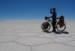 Hexagon-shaped salt edges: To
destroy the nice hexagonal salt edges not needlessly we also keep
quite well to the lanes (except around briefly a few photos to make). Hexagon-shaped salt edges: To
destroy the nice hexagonal salt edges not needlessly we also keep
quite well to the lanes (except around briefly a few photos to make).
|
| |
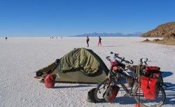
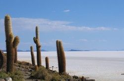 Isla Inkawasi: Though Isla Inkawasi is
not the only island on the Salar, however she lies where to herself
the main routes on the Salar cruise and, besides, still about a restaurant
disposes, it is the approach point for all tourist jeeps. The island
itself is covered with many old cacti (should be 1200 years old to).
Because the whole scenery lay here once under the sea covertly, there
are on the island still many corals what looks a little bit droll
up here on the Altiplano of course. We fill in our stores of water
with the restaurant again and then disappear on the quieter south
side of the islands around a few photo admissions to make. Here, actually,
we also want to whip our tent, because we can enjoy thus sundown as
well as from sunrise, however, suddenly a storm-like west wind starts,
so that we must proceed in the windbreak of the island and can make
to no nice sundown photos. Isla Inkawasi: Though Isla Inkawasi is
not the only island on the Salar, however she lies where to herself
the main routes on the Salar cruise and, besides, still about a restaurant
disposes, it is the approach point for all tourist jeeps. The island
itself is covered with many old cacti (should be 1200 years old to).
Because the whole scenery lay here once under the sea covertly, there
are on the island still many corals what looks a little bit droll
up here on the Altiplano of course. We fill in our stores of water
with the restaurant again and then disappear on the quieter south
side of the islands around a few photo admissions to make. Here, actually,
we also want to whip our tent, because we can enjoy thus sundown as
well as from sunrise, however, suddenly a storm-like west wind starts,
so that we must proceed in the windbreak of the island and can make
to no nice sundown photos. |
| |
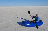 Paddking: Once in the life on a salt lake paddle I
imagined and make our Packrafts ready to be launched. Nevertheless,
unfortunately, I do not come anyhow so properly from the spot. This
is a nice lake if one can not even paddle on him.:-))) Paddking: Once in the life on a salt lake paddle I
imagined and make our Packrafts ready to be launched. Nevertheless,
unfortunately, I do not come anyhow so properly from the spot. This
is a nice lake if one can not even paddle on him.:-))) |
| |
 Marathon group: After we spend in the lee
of the island and when we the next morning with sunrise from the tent
have an eye we do not look badly when all at once a whole group of
joggers goes past!!! The group exists of 21 predominantly American
marathon runners who take a "run vacation" here in South America.
At the latest every 2nd day is run, and is denied every now and then
also a marathon (one is in a few days in the brine Titicaca).Für today
are attached on the Salar 21 km, before it further goes to Potosi.
Most runners are not acclimatised yet completely so optimally, finally,
we are on 3650 m, and thus they allow to concern it relatively quietly.
In the group is also a German marathon runner who has denied a marathon
on the North Pole in spite of his old age (nearly 70) only few weeks
ago. Marathon group: After we spend in the lee
of the island and when we the next morning with sunrise from the tent
have an eye we do not look badly when all at once a whole group of
joggers goes past!!! The group exists of 21 predominantly American
marathon runners who take a "run vacation" here in South America.
At the latest every 2nd day is run, and is denied every now and then
also a marathon (one is in a few days in the brine Titicaca).Für today
are attached on the Salar 21 km, before it further goes to Potosi.
Most runners are not acclimatised yet completely so optimally, finally,
we are on 3650 m, and thus they allow to concern it relatively quietly.
In the group is also a German marathon runner who has denied a marathon
on the North Pole in spite of his old age (nearly 70) only few weeks
ago. |
| |
|
 Salar Uyuni to push: According to our map
it looks thus as if it was to be driven substantially shorter by
Isla Inkawasi to north-east directly to Tacarani than about the
Salinas Garcia in the north. Without further ado we resolve to try
our luck. First everything still runs rather well and thus we come
to the east of the volcano Tunapa to a nice small place before a
gigantic herd Llamas puts out to pasture and with on a small
lagoon bulky flamingos are to be admired. I ask a Llamahirtin
which direction we should smash best of all around about the Salar
to Tacarani to come, however, unfortunately, woman has no notion
whether and what for places are on the other side of the Salar.
Thus we drive off roughly after feeling, because our compass has
a gigantic air bubble and is also not particularly helpful. Because
none of the lanes in the direction aimed by us leads we simply cycle
"quersalzein". The salt is nicely firm and crunches as really coldly
frozen snow. Nevertheless, after a while the salt becomes more humid,
we sink even something, and everywhere from the tyres it splashes
there. We change our direction a little bit southwards and come
so luckily again to more firm regions. Nevertheless, after some
kilometres the surface of the Salar changes once more and instead
of the nice smooth roadway with the hexagonal fields now it is very
rough and hubbelig. Our speed decreases from comfortable 18 km/h
on strenuous 10 km/h. After a while the salt becomes more humid
and softer again, and we become even slower. At last it goes off
in such a way that we must descend and push. Suddenly the salt changes
suddenly and we deal it with soft quite fine loose mud. Our heavy
bicycles deeply sink and thus we struggle laboriously pushing forward.
All together we push our wheels 7 km, before we reach firm reason
shortly before sundown again. To our joy we can see a few kilometres
farther a small village. Tacarani, as we hope. We cycle and push
on sandy runways in de small place where we shortly after sundown
come. As we are found out now we though not in Tacarani landed,
but in a little village with 3 families about 10 km farther to the
north, however because we anyhow want further to the north only
suits us. Nevertheless, at last from 50 km easy according to map
of stage (abbreviation) quite strenuous 80 km of day has become. Salar Uyuni to push: According to our map
it looks thus as if it was to be driven substantially shorter by
Isla Inkawasi to north-east directly to Tacarani than about the
Salinas Garcia in the north. Without further ado we resolve to try
our luck. First everything still runs rather well and thus we come
to the east of the volcano Tunapa to a nice small place before a
gigantic herd Llamas puts out to pasture and with on a small
lagoon bulky flamingos are to be admired. I ask a Llamahirtin
which direction we should smash best of all around about the Salar
to Tacarani to come, however, unfortunately, woman has no notion
whether and what for places are on the other side of the Salar.
Thus we drive off roughly after feeling, because our compass has
a gigantic air bubble and is also not particularly helpful. Because
none of the lanes in the direction aimed by us leads we simply cycle
"quersalzein". The salt is nicely firm and crunches as really coldly
frozen snow. Nevertheless, after a while the salt becomes more humid,
we sink even something, and everywhere from the tyres it splashes
there. We change our direction a little bit southwards and come
so luckily again to more firm regions. Nevertheless, after some
kilometres the surface of the Salar changes once more and instead
of the nice smooth roadway with the hexagonal fields now it is very
rough and hubbelig. Our speed decreases from comfortable 18 km/h
on strenuous 10 km/h. After a while the salt becomes more humid
and softer again, and we become even slower. At last it goes off
in such a way that we must descend and push. Suddenly the salt changes
suddenly and we deal it with soft quite fine loose mud. Our heavy
bicycles deeply sink and thus we struggle laboriously pushing forward.
All together we push our wheels 7 km, before we reach firm reason
shortly before sundown again. To our joy we can see a few kilometres
farther a small village. Tacarani, as we hope. We cycle and push
on sandy runways in de small place where we shortly after sundown
come. As we are found out now we though not in Tacarani landed,
but in a little village with 3 families about 10 km farther to the
north, however because we anyhow want further to the north only
suits us. Nevertheless, at last from 50 km easy according to map
of stage (abbreviation) quite strenuous 80 km of day has become.
|
| |
|
|
I
BOOKLET
available
for
DONATION!

50pages, 80 b/w photos, background
infos, stories, ...
Just send your donation
to our
Pay
Pal account: nadinepuschkasch@yahoo.de
and email us your post
address and we´ll send it to you.
|
| |
| |
|
Like to place your Ad here?
Just e-mail to:
martinlunz@yahoo.de
|
| |
| |
|
You
liked our website and like to contribute?
Our Pay
Pal account is: nadinepuschkasch@yahoo.de
|
|
| |
|
